

Hurricane Lala: 1.3 Trillion Gallons, 180K Without Power
Hurricane Lala became the first major hurricane of the 2026 Central Pacific season, reaching Category 4 strength with maximum sustained winds of 115 knots, or about 130 mph (215 km/h). Its central pressure fell to 947 mb at peak intensity. Lala remained offshore of the main Hawaiian Islands, but its rainbands brought heavy rainfall, flooding, damaging winds and widespread power outages across Hawaii.
University of Hawaii researchers estimated that Lala produced about 1.3 trillion gallons of rainfall across the state. Hawaii Island received roughly 66% of that total, while the statewide average rainfall reached about 11.4 inches. More than 250,900 customers were without power at the reported peak of the outages.
Two deaths were associated with Lala's impacts, including the death of a 90-year-old woman and a separate traffic-related death involving a man in his 60s. By August 28, Lala had weakened to a post-tropical cyclone with sustained winds of 35 knots and a central pressure of 1003 mb. Its final reported position was 38.2°N, 179.4°W.
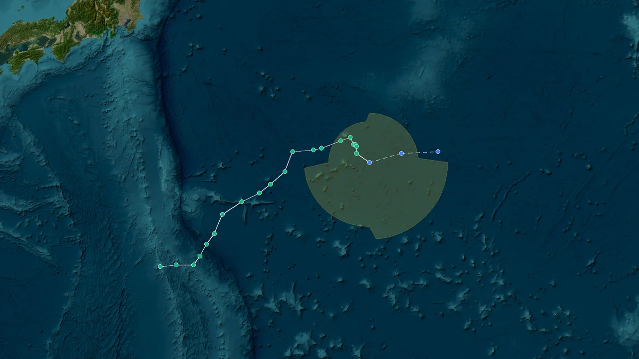
Origin and Track
Lala developed over the central Pacific and strengthened over warm ocean waters. On August 13, the system was classified as a tropical storm. From there, it continued to organize over the open ocean and eventually developed into a hurricane.
The storm was monitored as it strengthened and moved through the Central Pacific. Satellite observations and Dvorak intensity estimates helped forecasters assess changes in its organization and wind strength. As Lala intensified, the Central Pacific Hurricane Center continued to track its position and issue information for Hawaii.
Lala was a Central Pacific hurricane, not a Western Pacific typhoon. The Central Pacific Hurricane Center in Honolulu tracked it as CP012026 because the storm formed within the center's forecast area.
Regional weather agencies have different areas of responsibility. The Philippine Atmospheric, Geophysical and Astronomical Services Administration, Japan Meteorological Agency and China Meteorological Administration handle tropical cyclone monitoring and warnings in their respective regions. Lala remained a Central Pacific system under the responsibility of the Central Pacific Hurricane Center.
The storm's early development took place far from Hawaii, but its track eventually brought its circulation close enough for its outer bands and associated moisture to affect the islands. The center did not cross the main Hawaiian Islands. Instead, the strongest effects on land came from the combination of rainbands, tropical moisture and strong winds surrounding the offshore circulation.
Lala also accumulated 24.6 units of accumulated cyclone energy, or ACE, during its life cycle. ACE combines a tropical cyclone's intensity and duration into a single measure and is used by meteorologists to describe the amount of cyclone activity produced by a storm.
The progression from tropical storm on August 13 to a major hurricane later in the storm's life cycle marked a substantial increase in intensity. Lala ultimately reached Category 4 strength before beginning to weaken after its passage near Hawaii.
Close Call Near Hawaii
Lala approached Hawaii while maintaining a large enough circulation to affect the islands even though the center remained offshore. The storm stayed offshore, but its rainbands flooded Hawaii Island.
Heavy tropical moisture spread across parts of Hawaii as the rainbands moved over the islands. The combination of intense rainfall and Hawaii's mountainous terrain increased runoff in areas that received repeated bands of precipitation.
The storm did not need to make a direct landfall to produce significant effects. Strong winds reached communities outside the center's immediate path, while heavy rain affected roads, drainage systems, homes and other infrastructure.
Hawaii Island received the heaviest rainfall, with totals far exceeding the statewide average. About 66% of the state's total rainfall from Lala fell on the island.
The rainfall distribution reflected the way Lala's rainbands interacted with the islands. Areas closer to the storm's moisture plume received substantially more precipitation than locations farther from the main bands. Mountain slopes also influenced where rainfall accumulated.
Flooding became a major concern as rainfall continued. In areas where water accumulated faster than drainage systems could carry it away, roads and low-lying locations became vulnerable to flooding and difficult travel conditions.
Lala brought multiple hazards: intense rainfall, flash flooding, damaging winds and power failures. These effects did not occur only along a narrow track beneath the storm's center. The broader circulation allowed weather associated with the hurricane to reach a much wider portion of Hawaii.
The storm's offshore track also meant that its impacts had to be assessed separately from a traditional direct hurricane landfall. Although the center did not move across the main islands, the rainbands and wind field still produced significant consequences for residents and infrastructure.
Category 4 Peak
Lala reached Category 4 intensity on the Saffir-Simpson Hurricane Wind Scale. Its maximum sustained winds reached 115 knots, equivalent to about 130 mph or 215 km/h. Its minimum central pressure fell to 947 mb.
Category 4 hurricanes have maximum sustained winds of at least 130 mph and less than 157 mph under the Saffir-Simpson scale. Lala's 115-knot peak placed it within that range.
Lala was the first major hurricane of the 2026 Central Pacific season. Its peak intensity was assessed using satellite analysis, Dvorak intensity estimates and operational hurricane-center data.
The storm's strengthening over warm ocean waters allowed its circulation to become increasingly organized. As the storm intensified, its estimated maximum winds increased until it reached its 115-knot peak.
Pressure measurements also reflected the storm's strengthening. Lala's central pressure reached 947 mb at peak intensity. Lower central pressure is generally associated with a stronger tropical cyclone, although wind speed remains the basis for the Saffir-Simpson hurricane category.
After reaching Category 4 strength, Lala began to weaken. Its maximum winds declined as the storm moved away from its peak conditions. The weakening continued after the storm's effects had reached Hawaii.
The distinction between peak intensity and impacts on land is important in describing Lala. The storm's strongest winds occurred over the ocean, while Hawaii experienced a broader combination of rainfall, flooding, winds and power disruptions as the circulation passed nearby.
Lala's 24.6 ACE units also reflected the storm's period of sustained tropical cyclone activity. ACE does not represent a direct measure of damage or rainfall; it is an index based on the storm's intensity and duration.
By the end of its tropical life cycle, Lala had lost the characteristics needed to remain a hurricane. It was classified as post-tropical on August 28.
Rainfall and Flooding
Rainfall was one of the largest measurable effects of Lala across Hawaii. The estimated statewide total reached about 1.3 trillion gallons.
That volume is equivalent to a statewide average of approximately 11.4 inches of rainfall. The statewide figure is an average, so it does not mean every location received 11.4 inches. Rainfall varied considerably from one area to another.
Hawaii Island received approximately 66% of the total rainfall associated with Lala. That made the island the main focus of the storm's rainfall impacts.
The island's terrain played an important role in the distribution of precipitation. Hawaii Island contains high volcanic mountains and steep terrain, which can force moist air upward and enhance rainfall in favored areas.
Lala's rainbands repeatedly transported tropical moisture toward the islands. When those bands crossed the terrain, rainfall could become concentrated over particular areas rather than falling evenly across the state.
Heavy rainfall also created risks beyond the locations that received the highest measured totals. Water flowing downhill from higher elevations can affect roads, streams and low-lying communities. Rapid runoff can produce flash flooding even when a location is not directly beneath the storm's center.
The rainfall total also illustrates why Lala's effects cannot be measured only by maximum wind speed. The storm reached Category 4 strength over the ocean, but much of the disruption in Hawaii came from the interaction of rain, terrain, infrastructure and strong winds.
Flooding and rainfall can continue to affect communities after the main circulation has moved away. Roads may remain hazardous because of standing water, debris or damaged surfaces, while saturated ground can complicate cleanup and restoration work.
For Hawaii Island, the concentration of rainfall meant that local impacts could be substantially greater than the statewide average suggested. A statewide average of 11.4 inches provides a useful measure of the total event, but it does not capture the full variation in rainfall between individual locations.
The estimated 1.3 trillion gallons also places the storm's rainfall on a scale that is easy to distinguish from an ordinary heavy-rain event. The amount represents water accumulated across the entire state during the storm's passage.
Power Outages and Damage
Lala's winds and heavy weather disrupted electrical service across Hawaii. More than 42,000 customers were reported without power during an earlier stage of the storm's impact.
The number later rose above 250,900 customers at the reported peak. The difference between the early and peak figures reflects the continuing effects of the storm as additional areas experienced interruptions.
Strong winds can damage or interfere with electrical infrastructure through fallen vegetation, damaged lines and other equipment problems. Heavy rain and flooding can create additional obstacles for utility crews trying to inspect or repair affected systems.
Power outages also extend the effects of a storm beyond the period of strongest winds. Homes and businesses may lose lighting, communications, refrigeration and other essential services. Public agencies and emergency responders may also have to work around interruptions while roads and other infrastructure are being assessed.
Utility restoration requires more than simply identifying where electricity has failed. Crews must inspect equipment, determine whether lines and other components are safe to repair, and reach affected locations. Severe weather can delay that process when roads are blocked or conditions remain unsafe.
The reported peak of more than 250,900 customers without power shows the scale of the disruption associated with Lala. The outage total was substantially larger than the more than 42,000 customers reported during the earlier phase of the storm.
The power impacts occurred alongside rainfall and flooding rather than in isolation. Strong winds can bring down vegetation, while saturated ground and heavy rain can make access to damaged infrastructure more difficult.
The storm's offshore track did not prevent widespread utility impacts. A tropical cyclone's effects extend beyond the point occupied by its center, and Lala's circulation affected a broad area around Hawaii.
Restoration work continued as conditions improved and crews could safely inspect affected infrastructure. The return of electricity was an important part of the recovery process after the storm moved away.
The reported outage figures should also be distinguished from the number of people affected. Utility outage statistics count customers or service accounts, not necessarily individual residents. A single customer account can represent a household, business or other location serving multiple people.
Deaths and Recovery
Two deaths were associated with Lala's impacts. One involved a 90-year-old woman. A separate traffic-related incident resulted in the death of a man in his 60s.
These fatalities occurred in the broader context of the storm's effects, which included flooding, hazardous roads, strong winds and power outages. Not every storm-related death occurs directly beneath the hurricane's strongest winds; transportation and infrastructure hazards can also become part of the overall risk during a major weather event.
Emergency response and recovery activities continued after Lala weakened. Crews and authorities had to address flooding, road hazards, electrical interruptions and other consequences of the storm.
The scale of the event can be seen in several independent measurements. Lala produced an estimated 1.3 trillion gallons of rainfall across Hawaii, equivalent to a statewide average of about 11.4 inches. Hawaii Island received roughly 66% of that rainfall.
The storm also produced a major disruption to electrical service. More than 42,000 customers were without power during an earlier stage of the event, and the reported peak later exceeded 250,900 customers.
At sea, Lala reached maximum sustained winds of 115 knots and a minimum central pressure of 947 mb. Those measurements placed the storm at Category 4 intensity.
The combination of rainfall, wind and utility disruption meant that recovery extended beyond the time when the hurricane's strongest winds had ended. Flooded areas needed assessment, roads had to be checked and electrical infrastructure required inspection and repair.
The storm's classification changed as its structure weakened. By August 28, Lala had become a post-tropical cyclone. At that stage, it no longer met the criteria for a tropical cyclone, although the remnants of the system remained part of the broader weather pattern over the Pacific.
The final reported position was 38.2°N, 179.4°W. At that point, Lala had sustained winds of 35 knots and a central pressure of 1003 mb.
The final measurements show the extent of the storm's weakening from its Category 4 peak. Lala had declined from 115-knot maximum sustained winds and a 947-mb central pressure to 35-knot winds and a 1003-mb central pressure by August 28.
Lala's passage left a record of measurable rainfall, wind intensity, power disruption and human impacts across Hawaii. Its 2026 Central Pacific track began with tropical-storm status on August 13, reached Category 4 intensity over warm ocean waters, affected Hawaii while remaining offshore, and ended with its post-tropical classification on August 28.
FAQ
- How strong was Hurricane Lala at its peak?
Lala reached Category 4 strength on the Saffir-Simpson Hurricane Wind Scale. Its maximum sustained winds reached 115 knots, or about 130 mph (215 km/h), and its minimum central pressure was 947 mb.
- How much rain did Hurricane Lala bring to Hawaii?
Lala produced an estimated 1.3 trillion gallons of rainfall across Hawaii. The statewide average was about 11.4 inches, although actual rainfall varied considerably by location.
- Did Hurricane Lala make landfall in Hawaii?
No. Lala's center remained offshore rather than making a direct landfall on the main Hawaiian Islands. Its rainbands and broader wind field still affected Hawaii with heavy rain, flooding and damaging winds.
- How many people died in connection with Lala?
Two deaths were associated with the storm's impacts. One involved a 90-year-old woman, while a separate traffic-related incident resulted in the death of a man in his 60s.
- How many customers lost power during Hurricane Lala?
More than 42,000 customers were without power during an earlier stage of the storm. The reported peak later exceeded 250,900 customers.
- Which part of Hawaii received the most rainfall?
Hawaii Island received the heaviest rainfall and accounted for approximately 66% of the total rainfall associated with Lala across the state.
- When did Lala become a major hurricane?
Lala became a major hurricane when it reached at least Category 3 strength on the Saffir-Simpson scale. It ultimately strengthened to Category 4, with peak winds of 115 knots and a minimum central pressure of 947 mb.
Lala was first classified as a tropical storm on August 13. It later strengthened over warm ocean waters before reaching its peak intensity in the Central Pacific.
- What happened to Lala after it affected Hawaii?
Lala weakened after reaching its peak and continued to lose tropical characteristics as it moved away from Hawaii. On August 28, it was classified as a post-tropical cyclone. Its final reported position was 38.2°N, 179.4°W, with sustained winds of 35 knots and a central pressure of 1003 mb.