

Tropical Storm Nangka 2026: Short-Lived System Turns Northeast
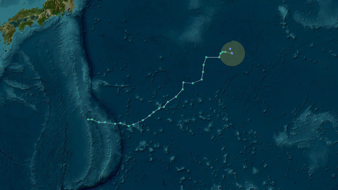
Tropical Storm Nangka formed over the western North Pacific on August 12, 2026, becoming Typhoon No. 17 in the Japan Meteorological Agency's annual numbering system. At 8:00 a.m. Beijing Time, the center was near 21.8°N, 141.7°E, with central pressure around 998 hPa and maximum winds near 18 m/s. Its intensity remained relatively weak, with central pressure near 998 hPa at formation and around 994 hPa in subsequent observations. Nangka then turned northeast over open Pacific waters and weakened, with the Joint Typhoon Warning Center issuing its final warning at 1200 UTC on August 14.
Nangka's 2026 story was primarily a story of track rather than landfall. The cyclone formed well east of the Philippines, strengthened for a short period, remained outside the Philippine Area of Responsibility, avoided the South China Sea, and then recurved toward the northeast over the Pacific.
That track sharply limited the storm's direct exposure to the major coastal population centers of the Philippines, China, Vietnam, and Japan. The system still required coordinated monitoring because tropical-cyclone position and intensity can change rapidly in the western North Pacific, but its observed path kept the strongest part of the circulation over open water.
This retrospective follows the operational record through August 15, 2026, separating JMA, CMA, JTWC, and PAGASA terminology where their measurement conventions or warning responsibilities differ.
For live storm positions, readers can use the StormAtlasX weather monitoring tools
to compare current storm locations, wind fields, pressure trends, and forecast information. Historical comparisons are available through the StormAtlasX historical typhoon database
.
Formation in the Western North Pacific: Nangka Takes Shape Far From Land
Nangka developed in the western North Pacific, the principal tropical-cyclone basin east of East Asia. The region contains several common pathways for tropical cyclones: westward toward the Philippines and South China Sea, northwestward toward Taiwan and China, northward toward the Ryukyu Islands and Japan, or northeastward into the open Pacific.
Nangka followed the last of those pathways.
On August 12, 2026, Chinese operational reporting placed the storm's center at approximately 21.8°N, 141.7°E at 8:00 a.m. Beijing Time. The reported central pressure was 998 hPa, while maximum winds near the center reached about 18 m/s.
Japan's Meteorological Agency assigned the system the annual designation Typhoon No. 17. The regional international name was Nangka, a name contributed by Malaysia to the western North Pacific and South China Sea naming list.
The initial coordinates immediately established the storm's geographical character. Nangka was east of the Philippines and far from mainland China and Vietnam. It was also well south of the Japanese main islands. There was therefore a large area of open ocean between the circulation and the major East Asian population centers.
That separation became increasingly important as the storm moved.
Why the Formation Location Matters
A tropical cyclone's intensity cannot be evaluated independently of its position. A storm with moderate winds over open water creates a very different risk profile from an equally strong system approaching a densely populated coastline.
At formation, Nangka was far enough offshore that its strongest winds remained primarily a marine concern. The storm was nevertheless significant enough to require regional monitoring, particularly because the western North Pacific contains multiple potential steering patterns.
A change in the subtropical steering environment can redirect a tropical cyclone toward the Philippines, Taiwan, China, Japan, or the open Pacific. Operational centers therefore track systems even when the immediate land threat is low.
Nangka's subsequent movement showed why early track monitoring matters. Rather than maintaining a westward trajectory, the cyclone moved northward and then northeastward.
That change reduced its potential exposure to the Philippines and the South China Sea.
Western North Pacific Versus South China Sea
The terms western North Pacific and South China Sea describe related but geographically distinct areas.
The western North Pacific is the larger regional basin in which Nangka formed. The South China Sea is a separate subregion farther west, bounded by the Philippines, Taiwan, China, Vietnam, Malaysia, Brunei, and surrounding waters.
Tropical cyclones that move into the South China Sea can threaten southern China and Vietnam even when their centers remain offshore. Their rainfall bands can also affect inland areas well before the center reaches land.
Nangka did not take that route.
The 2026 cyclone remained over the western North Pacific and subsequently turned northeast. It therefore never developed into a South China Sea tropical cyclone threatening Hainan, Guangdong, Guangxi, or northern Vietnam.
For readers monitoring basin boundaries and storm movement, the StormAtlasX western North Pacific storm tracker
provides a geographic reference for distinguishing the broader basin from individual subregions.
The Nangka Name and Regional Naming System
The name Nangka comes from Malaysia and refers to jackfruit. Malaysia contributed the name to the regional tropical-cyclone naming system administered through the ESCAP/WMO Typhoon Committee framework.
Storm names are assigned sequentially from the regional list once a qualifying tropical cyclone receives an official name. The appearance of a name on the list does not itself mean that a storm has formed.
In 2026, Nangka became an operational storm name after the system reached the required classification in the western North Pacific.
JMA, as the Regional Specialized Meteorological Center for the western North Pacific, provides official regional tropical-cyclone information. Other agencies, including CMA and JTWC, publish their own operational analyses and warnings according to their respective responsibilities.
Those products can use different wind averaging periods and analysis techniques. A retrospective should therefore preserve the source of each intensity value instead of treating every reported number as directly interchangeable.
The Initial Coordinates and East Asian Exposure
Nangka's initial location near 21.8°N, 141.7°E was one of the most important facts in the entire event.
At that position, the circulation was not approaching the Chinese coast from the South China Sea. It was not crossing the Philippines. It was not moving toward Vietnam. It was not immediately threatening the Japanese archipelago.
The storm instead had open ocean in almost every direction.
That does not make a tropical cyclone harmless. Strong winds can endanger vessels, aviation operations can be disrupted, and large swells can spread well away from the storm center. But the physical consequences on populated land depend heavily on how close the cyclone gets to the coast.
Nangka never made that transition from primarily maritime system to major coastal threat.
Peak Intensity: A Brief Strengthening Before the Northeast Turn
Nangka strengthened after formation, but the intensification phase remained short. The central pressure declined from approximately 998 hPa at formation to around 994 hPa in subsequent JMA observations.
JMA observations on August 13 placed maximum instantaneous wind near 90 km/h, or approximately 25 m/s.
Those values indicate a defined tropical cyclone circulation but not the extreme intensity associated with the strongest western North Pacific typhoons.
The pressure fall was measurable, yet Nangka did not undergo the dramatic rapid intensification associated with some major typhoons. Its strongest phase was also brief because the storm soon moved into a different steering and environmental regime.
The August 13 Strengthening Phase
The decrease in central pressure from approximately 998 hPa to 994 hPa showed that Nangka's circulation became somewhat better organized after formation.
JMA's observation of roughly 90 km/h maximum instantaneous wind provided an additional indication of the storm's peak operational intensity.
When comparing that figure with JTWC values, however, readers should account for the different wind definitions used by the agencies. JMA commonly reports maximum instantaneous wind, while JTWC's warning products use maximum sustained wind based on a different averaging period.
The numerical values therefore should not be combined into a single artificial "average" intensity.
The important operational fact is that Nangka strengthened modestly and briefly before its northeastward movement became the defining feature of the storm.
Why the Northeast Turn Changed the Risk
The storm's change in direction was more consequential for East Asian risk than its modest pressure decline.
A tropical cyclone moving west or northwest across the Philippine Sea can bring increasing exposure to Luzon, Taiwan, the Ryukyu Islands, mainland China, or the South China Sea.
Nangka instead turned toward the northeast.
That movement carried the circulation away from the Philippines and away from the South China Sea. It also reduced the likelihood of a direct Japanese landfall as the storm weakened over the Pacific.
This distinction matters when assessing physical risk.
The same wind speed can produce very different consequences depending on whether it occurs over open ocean or near a densely populated coastline. A tropical cyclone with winds near 90 km/h over the Pacific is principally a marine hazard. A similar circulation approaching a major coastal city can produce damaging winds, storm surge, heavy rainfall, flooding, transport disruption, and widespread power outages.
Nangka's track kept those hazards away from the major East Asian coastal population centers.
The Philippines and the Philippine Area of Responsibility
PAGASA monitored Nangka in relation to the Philippine Area of Responsibility, or PAR.
The PAR is an operational geographic area used by PAGASA for tropical-cyclone monitoring and warning. A system outside the PAR can still be watched closely if it has the potential to enter the area or affect Philippine weather, but being outside the PAR is not equivalent to making landfall in the Philippines.
Nangka remained outside the PAR during the relevant August 12–13 monitoring period.
That geographic fact also explains why the storm did not develop into a Philippine landfall event accompanied by a progression of Tropical Cyclone Wind Signals No. 1 through No. 5.
PAGASA's local warning signals are designed to communicate expected wind impacts over Philippine localities. They should not be assigned to an offshore cyclone simply because the cyclone has an international name.
There was no verified direct Nangka landfall in the Philippines.
Why "Bagyong Nangka" Requires Context
PAGASA uses local names for tropical cyclones affecting or entering its area of responsibility. Philippine media may therefore use the term Bagyong Nangka when a system receives a local Philippine name.
For the 2026 event, however, Nangka remained outside the PAR during the relevant monitoring period. The storm did not become a Philippine landfall event and did not generate a verified local wind-signal episode associated with direct land impact.
This distinction prevents a common reporting error: treating the international storm name as proof that the cyclone crossed Philippine territory.
The name identifies the regional cyclone. The PAR position determines whether PAGASA's local warning framework applies.
No South China Sea Threat Developed
The storm's northeastward movement also eliminated the possibility of a conventional Nangka threat to the South China Sea.
Had the cyclone moved westward, forecasters would have had to assess potential effects on the northern Philippines, Taiwan, southern China, and Vietnam.
Instead, the circulation remained in the western North Pacific.
There was therefore no verified Nangka landfall in Hainan, Guangdong, Guangxi, or Vietnam. The cyclone did not cross the basin that typically brings tropical systems into direct proximity with those coastal regions.
For historical comparison, the StormAtlasX historical typhoon database
can be used to compare Nangka 2026 with earlier storms that followed much farther westward tracks.
Final Warning Over Open Water: Nangka Weakens Away From East Asia
By August 14, Nangka was weakening as it moved farther northeast over the Pacific.
The Joint Typhoon Warning Center issued its final warning at 1200 UTC on August 14, 2026. At that stage, JTWC identified the system as Tropical Depression 16W (Nangka).
The final-warning position was approximately 28.3°N, 154.5°E.
JTWC estimated maximum sustained winds near 25 knots, with gusts around 35 knots. The system's late-stage pressure was reported near 999 hPa in the operational record used for this retrospective.
The final position illustrates the storm's rapid geographical shift. Nangka had formed near 21.8°N, 141.7°E. By the final warning, the circulation was near 28.3°N, 154.5°E.
The storm had therefore moved strongly north and east while weakening.
From Tropical Cyclone to Dissipating Depression
Tropical cyclones depend on a combination of warm ocean water, atmospheric moisture, organized convection, and a favorable wind environment.
As a system moves away from its original tropical environment, one or more of those supporting factors can weaken. The circulation becomes less organized, convection diminishes, and the storm eventually loses its tropical-cyclone structure.
That process occurred with Nangka.
The final JTWC warning placed the system at only about 25 knots of maximum sustained wind. This was substantially weaker than the circulation's earlier peak.
The system was also far from the major East Asian coastal areas that would have faced a greater threat if the cyclone had retained its strength.
The Final Position and Coastal Risk
The final coordinates near 28.3°N, 154.5°E were well over the open Pacific.
At that stage, Nangka was east of Japan and far from mainland China, the Philippines, Taiwan, and Vietnam.
The geographic separation meant that the remaining tropical-depression circulation did not represent a major direct land threat.
Marine interests remained the primary concern. Even a weakening tropical cyclone can produce rough seas, locally strong winds, and hazardous conditions for vessels near the circulation.
But the storm's weakening and northeastward movement meant that its direct terrestrial impact remained limited.
China: No Nangka Landfall
There was no verified 2026 Nangka landfall on mainland China.
The storm formed too far east to begin with and subsequently moved away from the westward coastal corridor.
China's coastal provinces routinely monitor western North Pacific cyclones because track changes can bring storms toward the East China Sea, Taiwan Strait, South China Sea, or mainland coast.
Nangka did not make that transition.
There was therefore no basis for attributing a mainland Chinese landfall, storm-surge disaster, or major coastal wind event to the 2026 system.
Vietnam: No South China Sea Crossing
Vietnam was likewise outside Nangka's direct landfall path.
The most important fact for Vietnam was not simply the storm's intensity but its basin trajectory. Nangka did not enter the South China Sea, so it never developed the geographic proximity required for a direct Vietnamese coastal impact.
That differentiates the 2026 storm from earlier Nangka systems that crossed the South China Sea.
Japan: Monitoring Without Direct Landfall
Japan remained part of the broader regional monitoring picture because the western North Pacific routinely produces cyclones that curve toward the Japanese archipelago.
Nangka's northeastward movement, however, kept the circulation offshore.
The system weakened as it traveled toward the open Pacific rather than approaching the Japanese mainland with sufficient strength to produce a direct landfall.
This is an important distinction between being monitored by JMA and affecting Japan directly. JMA's regional responsibility covers a very large portion of the western North Pacific, including many storms that never approach Japanese territory.
The Philippines: No Direct Landfall
Nangka did not make landfall in the Philippines.
The cyclone remained outside the PAR during the relevant period and then moved northeastward.
The absence of a Philippine landfall also means that claims about specific Philippine casualties, structural damage, or local wind-signal impacts require independent verification rather than being inferred from the existence of the storm itself.
For future events, readers should check PAGASA's official warning products and the StormAtlasX Philippine storm monitoring guide
rather than relying on international storm names alone.
Historical Nangka Storms: Same Name, Different Meteorological Events
Nangka is a recurring name in the western North Pacific naming system. Earlier storms carrying the same name had very different tracks and intensities.
That history matters when interpreting archived storm reports.
A tropical cyclone name is an identifier, not a permanent description of a particular storm's strength or impact. When the naming list cycles, the same name can be assigned to a completely new weather system years later.
Nangka in 2020
The 2020 Nangka followed a much different route from the 2026 cyclone.
The 2020 system crossed the South China Sea and affected Hainan before moving toward northern Vietnam. Its track brought the storm into a region where heavy rainfall and coastal weather effects could directly affect populated land.
That is fundamentally different from the 2026 Nangka track.
In 2026, Nangka remained in the western North Pacific and recurved northeastward. It never entered the South China Sea and never made a direct landfall in Vietnam or mainland China.
The same storm name should therefore never be used as evidence that the 2026 cyclone produced the impacts documented for the 2020 storm.
Nangka in 2015
The 2015 Nangka was also much stronger than the 2026 system.
The 2015 cyclone developed into a powerful typhoon over the western North Pacific and maintained a much longer life cycle. Its track eventually brought the system toward Japan.
The contrast with 2026 is substantial.
The 2015 storm had a considerably stronger wind field and lower central pressure, while the 2026 system remained relatively weak and dissipated over the Pacific shortly after its northeastward turn.
Historical intensity values therefore need to be tied to the correct year before publication.
Why Same-Name Storms Cause SEO and Reporting Errors
Search engines often return historical pages for a storm name without automatically distinguishing every year.
A query for "Nangka typhoon" can therefore surface information about 2015, 2020, or 2026.
That creates a specific editorial risk: an article may accidentally combine the 2020 landfall history with the 2026 track, or use the 2015 peak intensity when describing the 2026 cyclone.
The correct procedure is to verify:
The year of formation.
The agency identifier.
The formation coordinates.
The best-track date and time.
The central pressure.
The wind-speed convention.
The landfall location, if any.
The final warning or dissipation record.
For historical research, readers can use the StormAtlasX typhoon track archive
alongside official meteorological agency records.
Operational Data Versus Final Best Track
A retrospective published shortly after a cyclone's dissipation may rely on operational data rather than a finalized post-season best track.
JMA distinguishes preliminary operational values from later post-analysis values. Coordinates and intensity estimates can therefore change after additional satellite, surface, and numerical-analysis information becomes available.
The August 15, 2026 record should consequently be understood as an operational retrospective, not necessarily the final immutable best-track analysis.
This distinction is especially important for a short-lived storm such as Nangka because small changes in the analyzed position or peak intensity can alter the reported lifetime and maximum strength without changing the broader physical story.
The broader story remains clear: formation in the western North Pacific, modest strengthening, a northeastward turn, and weakening over open Pacific waters.
Default Best Recommendation: Follow the Track, Not the Name
For readers assessing a tropical cyclone such as Nangka, the most useful sequence is to check location first, intensity second, and projected movement third.
The name identifies the system. The track determines who is exposed.
Nangka formed near 21.8°N, 141.7°E, far east of the Philippines. Its pressure subsequently fell to around 994 hPa, and JMA observed maximum instantaneous winds near 90 km/h. Those measurements establish that the storm strengthened after formation, but they do not by themselves indicate a major coastal threat.
The northeastward track changed the outcome.
Nangka did not enter the South China Sea. It did not make landfall in the Philippines, China, Vietnam, or Japan. By the final JTWC warning, the system was near 28.3°N, 154.5°E, with maximum sustained winds around 25 knots.
For current storms, the StormAtlasX weather monitoring tools
can help readers follow position and intensity changes. For past storms, the historical typhoon database
provides a way to compare tracks across different years.
Local warnings should always come from the relevant national meteorological authority.
For the Philippines, PAGASA provides PAR information and Tropical Cyclone Wind Signals. For Japan and the broader western North Pacific, JMA provides regional tropical-cyclone analysis. China's National Meteorological Center provides mainland warnings and typhoon information. Vietnam's national meteorological authorities issue local warnings when tropical cyclones threaten Vietnamese waters or land.
This division of responsibilities matters because agencies may publish different wind values, classifications, and forecast products while describing the same physical system.
A storm's name does not determine its impact—its position, intensity, and track do.
FAQ: Nangka 2026 Facts, Track and Impacts
- When did Tropical Storm Nangka form in 2026?
Nangka formed on August 12, 2026, over the western North Pacific. Chinese operational reporting at 8:00 a.m. Beijing Time placed the center near 21.8°N, 141.7°E.
- Where did Nangka form?
Nangka formed near 21.8°N, 141.7°E, over the western North Pacific. The location was well east of the Philippines and far from mainland China and Vietnam.
- What was Nangka's central pressure at formation?
The initial central pressure reported in Chinese operational information was approximately 998 hPa.
- What was Nangka's maximum reported intensity?
JMA observations during the stronger phase placed central pressure near 994 hPa and maximum instantaneous wind near 90 km/h, or approximately 25 m/s.
- Was Nangka Typhoon No. 17?
Yes. JMA's annual numbering system identified Nangka as Typhoon No. 17 in 2026.
- Was Nangka a tropical storm or a typhoon?
Classification can differ by agency because agencies use different wind definitions and operational systems. JMA numbered Nangka as Typhoon No. 17, while JTWC's final warning identified the weakening system as Tropical Depression 16W. The safest comparison is to cite the agency and its associated wind convention.
- Did Nangka enter the Philippine Area of Responsibility?
No. PAGASA monitored Nangka in relation to the Philippine Area of Responsibility, but the cyclone remained outside the PAR during the relevant August 12–13 period.
- Did Nangka become a Philippine landfalling Bagyong?
No. There was no direct Philippine landfall associated with the 2026 Nangka. Because the storm remained outside the PAR, it did not become a conventional Philippine landfall event.
- Did PAGASA issue Tropical Cyclone Wind Signal No. 1?
There is no verified basis for describing Nangka as producing a Philippine Tropical Cyclone Wind Signal No. 1–5 event. The system remained offshore and did not develop into a direct Philippine wind threat.
- Did Nangka enter the South China Sea?
No. The 2026 Nangka remained in the western North Pacific and turned northeastward instead of crossing into the South China Sea.
- Did Nangka hit the Philippines?
No. There was no direct Philippine landfall associated with Nangka in August 2026.
- Did Nangka hit China?
No. There was no verified Nangka landfall on mainland China. The storm remained offshore and turned northeastward.
- Did Nangka affect Vietnam?
There was no verified direct Nangka landfall in Vietnam. The cyclone did not enter the South China Sea, which kept it away from the main Vietnamese coastal threat corridor.
- Did Nangka hit Japan?
No direct Japanese landfall is documented for the 2026 system. Nangka moved northeast over the Pacific and weakened before reaching the Japanese archipelago.
- When did JTWC issue the final warning for Nangka?
JTWC issued its final warning at 1200 UTC on August 14, 2026.
- Where was Nangka when JTWC issued the final warning?
The final-warning position was approximately 28.3°N, 154.5°E, over the open Pacific.
- How strong was Nangka at the final warning?
JTWC classified Nangka as a tropical depression with maximum sustained winds near 25 knots and gusts around 35 knots.
- What happened to Nangka after the final warning?
The tropical cyclone continued to weaken over the Pacific and lost its remaining tropical organization. The final JTWC warning marked the end of active tropical-cyclone advisories for the system.
- Did Nangka cause major damage in East Asia?
There is no verified evidence in the operational record of a major land disaster caused by Nangka in China, the Philippines, Vietnam, or Japan. The storm's offshore track sharply limited its direct land exposure.
- Was Nangka a major typhoon?
No. The 2026 system remained relatively weak compared with major western North Pacific typhoons. Its strongest documented phase featured pressure near 994 hPa and JMA maximum instantaneous winds around 90 km/h.
- Why do JMA and JTWC report different wind speeds?
JMA and JTWC use different operational procedures and wind averaging periods. JMA's maximum instantaneous wind should not be treated as numerically identical to JTWC's maximum sustained wind.
- What does the name Nangka mean?
Nangka is the Malay name for jackfruit. Malaysia contributed the name to the regional western North Pacific and South China Sea tropical-cyclone naming list.
- Which country contributed the name Nangka?
Malaysia contributed the name Nangka to the regional naming system.
- Has there been a Nangka before 2026?
Yes. Nangka has been assigned to earlier western North Pacific tropical cyclones, including storms in 2015 and 2020.
- Was the 2020 Nangka the same storm as the 2026 Nangka?
No. They were separate tropical cyclones from different years. The 2020 Nangka crossed the South China Sea and affected Hainan and northern Vietnam, while the 2026 Nangka remained in the western North Pacific and turned northeast.
- Was the 2015 Nangka stronger than the 2026 Nangka?
Yes. The 2015 Nangka became a much stronger typhoon and maintained a longer life cycle than the short-lived 2026 system.
- Why can the same storm name appear in different years?
The western North Pacific and South China Sea use a rotating regional naming list. Names are reused after the list cycles, except when a name is removed or replaced under the relevant regional procedures.
- Was Nangka a threat to Taiwan?
The 2026 Nangka track did not bring the cyclone into a direct Taiwan landfall corridor. It remained east of the Philippines and then turned northeast.
- Was Nangka a threat to Hong Kong?
No direct Nangka threat to Hong Kong was documented. The storm remained far to the east and did not enter the South China Sea.
- Why did Nangka have limited land impacts?
Its track was the main reason. The cyclone formed far offshore, remained outside the PAR, avoided the South China Sea, turned northeast, and weakened over the Pacific.
- What is the most important coordinate in the Nangka record?
The formation coordinate, 21.8°N, 141.7°E, establishes where the cyclone began. The final-warning coordinate, approximately 28.3°N, 154.5°E, shows how far north and east the storm moved before weakening.
- Can Nangka's intensity values still be revised?
Yes. Operational tropical-cyclone analyses can be revised during later post-analysis. JMA distinguishes preliminary operational data from later analyzed values, so future historical datasets may contain small changes to positions, pressures, or winds.
- Where can I monitor future tropical cyclones?
Readers can use the StormAtlasX weather monitoring tools
for storm positions and meteorological information, while official national agencies remain the authoritative source for warnings.
- Where can I compare Nangka with previous typhoons?
The StormAtlasX historical typhoon database
provides a dedicated historical comparison point for previous tropical cyclones and their tracks.
- What is the main meteorological characteristic of Nangka 2026?
Nangka was a short-lived western North Pacific cyclone that strengthened modestly and then recurved northeastward over open Pacific waters. Its track, rather than extreme intensity, defined its 2026 impact profile.
Conclusion: Nangka Ends as a Pacific Marine System
Nangka's 2026 life cycle followed a compact sequence: formation on August 12, modest strengthening, a northward and northeastward turn, and weakening over the open Pacific by August 14.
The cyclone formed near 21.8°N, 141.7°E with central pressure around 998 hPa and maximum winds near 18 m/s in Chinese operational reporting. Subsequent JMA observations placed the central pressure near 994 hPa and maximum instantaneous wind around 90 km/h.
The storm never entered the South China Sea and did not make a direct landfall in the Philippines, mainland China, Vietnam, or Japan. Its movement away from the western Pacific landfall corridors kept the strongest part of the circulation offshore.
By the JTWC final warning at 1200 UTC on August 14, Nangka was near 28.3°N, 154.5°E, with maximum sustained winds around 25 knots and a weakening tropical-depression circulation over the Pacific.
The final operational record therefore closes with Nangka moving northeastward over open water, away from the major East Asian coastal population centers, as its tropical circulation weakened.