
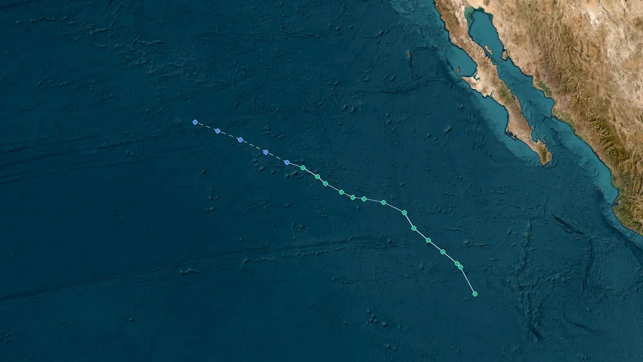

Tropical Storm Julio Absorbed by Iselle Less Than 24 Hours After Forming
Tropical Depression Ten-E formed over the eastern Pacific on August 24. It strengthened into Tropical Storm Julio on August 25. Julio's circulation opened into a trough later that day. The remnants were absorbed into nearby Tropical Storm Iselle.
Julio's operational history lasted only about one day as a tropical cyclone, but the system went through several distinct stages during that short interval. It formed near 13.5°N, 120.8°W, strengthened to a named tropical storm, reached maximum sustained winds of 45 kt, and then lost its closed circulation while moving north toward Iselle. The National Hurricane Center issued five advisories for the system, with the final advisory at 2100 UTC on August 25 identifying the circulation as remnants rather than a tropical cyclone.
Julio remained over the open eastern North Pacific throughout its life cycle. Its track stayed near 120°W, thousands of kilometers east of the Philippines and outside the Western Pacific and South China Sea basins. No coastal watches or warnings were issued for Julio, and the final advisory listed no land hazards.
From Depression to Storm: Julio's Rapid Rise and Faster Fall
The system that became Julio was first classified operationally as Tropical Depression Ten-E at 2100 UTC on August 24. Its center was analyzed near 13.5°N, 120.8°W, with maximum sustained winds of 30 kt and a minimum central pressure of 1006 mb. The depression was moving north at about 8 kt over open ocean.
At that stage, the system was compact and still organizing. Deep convection was concentrated around a low-level circulation, while the surrounding atmospheric pattern was already being shaped by the nearby circulation of Iselle. The forecast environment gave Ten-E a narrow opportunity to strengthen before interaction with the larger cyclone became the dominant feature of its evolution.
Six hours later, at 0300 UTC on August 25, Ten-E was near 14.5°N, 120.3°W. The system remained a 30-kt tropical depression with a central pressure of 1006 mb. Its motion had turned toward the north-northeast, with forward speed increasing to roughly 9 kt.
The change in movement was important to the storm's short history. Ten-E was not drifting slowly in place while consolidating. It was accelerating northward toward a region where the circulation of Iselle exerted increasing influence. That movement left little time for the depression to establish a durable inner core.
At 0900 UTC on August 25, the National Hurricane Center upgraded Ten-E to Tropical Storm Julio. The center was near 15.7°N, 119.8°W, maximum sustained winds had reached 35 kt, and the estimated minimum central pressure was 1003 mb. The storm was moving north-northeast at approximately 11 kt. The eastern Pacific storm identifier was EP102026.
Marine Weather
Julio's naming came during a period of rapid change in its surrounding environment. Iselle was already the larger and stronger cyclone to the west-northwest. The two circulations were close enough for their outer wind fields and surrounding pressure patterns to interact, while Julio's own convective structure remained much smaller.
The official naming record places Julio firmly in the eastern North Pacific. The 2026 eastern Pacific name list included Iselle followed by Julio, and EP102026 was the operational identifier assigned to the storm.
That basin assignment is reflected in Julio's entire track. The storm never crossed into the Western Pacific, never entered the South China Sea, and never approached the Philippine archipelago. Its longitude remained around 120°W as it moved northward.
The short distance in time between formation and dissipation also distinguishes Julio from a conventional long-lived tropical storm. Ten-E formed at 2100 UTC on August 24. Julio became a tropical storm at 0900 UTC on August 25. By 2100 UTC that same day, the National Hurricane Center had already declared that the circulation was no longer a tropical cyclone. The named phase lasted roughly 12 hours.
The rapid transition was not caused by land interaction. Julio remained hundreds of nautical miles offshore and encountered no mountain ranges, continental friction, or coastal terrain. Its weakening was an atmospheric and structural process occurring entirely over the ocean.
Satellite observations showed that the circulation was becoming less organized as Julio moved north. Convection no longer remained tightly aligned with the low-level center, and the surrounding shear increasingly affected the storm's ability to maintain a coherent vortex.
The nearby Iselle circulation provided the larger-scale framework. At 2100 UTC on August 25, Iselle was centered near 21.0°N, 121.8°W, with maximum sustained winds of 50 kt and a minimum central pressure of 994 mb. The eastern Pacific tropical weather discussion described Iselle as the dominant circulation while also placing Julio's remnants near 21.0°N, 119.5°W.
The relative positions explain the final phase of Julio's track. Julio was east of Iselle and moving north. Iselle was moving west-northwest. As Julio's circulation weakened, the two systems moved toward a configuration in which the remaining vorticity of the smaller system could be incorporated into the larger circulation.
Julio's history was consequently compressed into a sequence of formation, brief strengthening, peak intensity, structural deterioration and absorption. There was no prolonged mature phase between the storm's maximum intensity and its disappearance.
Peak at 18°N: Julio's 45-Knot Moment Before Collapse
Julio reached its strongest analyzed wind intensity at 1500 UTC on August 25 near 18.0°N, 118.9°W. Maximum sustained winds were 45 kt, and the center was moving north-northeast at approximately 19 kt. The operational storm record placed the system about 630 nautical miles west of the southern tip of Baja California at the time of its final advisory later that day.
Cape Weather
The 45-kt peak represented a modest but genuine increase from the 35-kt intensity recorded when Julio was named. The storm had managed to organize enough convection and circulation to cross from depression strength into the tropical-storm category and then strengthen further.
Julio's peak was brief. The storm did not establish a long-lived mature core after reaching 45 kt. Instead, its circulation soon became increasingly exposed as convection shifted away from the center.
The pressure record requires careful handling in a retrospective. Satellite-based storm displays have listed a pressure near 1001 mb around the 1500 UTC peak, while the final operational advisory issued by the National Hurricane Center reported a minimum central pressure of 1003 mb for the remnant circulation. The official final advisory is the appropriate baseline for the completed operational record, so this retrospective uses 1003 mb rather than presenting 1001 mb as a confirmed best-track minimum.
GOES Image Viewer
The wind estimate is similarly best expressed using the operational unit of knots. Julio's peak was 45 kt. The final advisory reduced the analyzed wind to 40 kt as the circulation opened into a trough. The final forecast advisory placed 34-kt winds within portions of the northeastern and southeastern quadrants, illustrating the asymmetry of the weakening circulation.
Julio's brief life illustrates how a cyclone can reach tropical-storm intensity while lacking the structure to sustain a closed circulation. Maximum wind speed is only one part of a tropical cyclone's physical state. A storm also needs a persistent low-level center, organized convection and an environment that allows those features to remain coupled.
Those conditions were deteriorating rapidly.
Vertical wind shear increasingly displaced the deepest thunderstorms from the circulation center. In a well-organized tropical cyclone, persistent convection near the center helps maintain the warm-core structure and the pressure gradient that supports the wind field. When convection becomes displaced or fragmented, the low-level vortex can weaken even while strong winds remain temporarily present around the broader circulation.
Julio's acceleration northward added another feature to the evolution. At formation, the system was moving north at roughly 8 kt. By the final advisory, the remnants were moving north at 22 kt in the forecast advisory and about 25 mph in the public advisory. The storm therefore covered its northward track quickly during its final hours.
The storm's strongest winds were also not associated with a major coastal threat. Julio was far offshore, and its tropical-storm-force wind field remained over open water. The final advisory explicitly recorded no hazards affecting land.
That offshore setting separated Julio from the coastal impacts commonly associated with tropical cyclones in the Western Pacific and South China Sea. There was no Philippine landfall, no Chinese coastal warning attributable to Julio, and no Japanese or Vietnamese impact associated with its circulation.
The meteorological interest instead lies in the interaction between a small, fast-moving tropical cyclone and a larger neighboring system. Julio did not need to reach hurricane strength for the interaction to become decisive. The system's structural integrity deteriorated before it could sustain its peak intensity.
At 1800 UTC on August 25, the center had moved to about 19.5°N, 118.8°W. Three hours later, the final advisory placed the remnants at 21.0°N, 119.5°W. The center had moved roughly 1.5 degrees north in three hours, while the circulation itself was no longer closed.
The result was a storm whose strongest phase was almost immediately followed by its final operational classification. Julio reached 45 kt at 1500 UTC and was declared no longer a tropical cyclone six hours later.
The rapid sequence is the defining feature of the storm's intensity history. It was not a case of gradual weakening over several days. It was a compact cycle in which the storm developed, peaked and lost its identity within the same calendar day.
Absorption and End: How Iselle Swallowed Julio's Remnants
At 2100 UTC on August 25, the National Hurricane Center issued its final advisory on Julio. The circulation was centered near 21.0°N, 119.5°W, with maximum sustained winds of 40 kt and a minimum central pressure of 1003 mb. The system was moving north at 22 kt.
The key observation was structural rather than numerical. Satellite and microwave data showed that Julio's circulation had opened into a trough of low pressure. Once the closed circulation was gone, Julio no longer met the operational definition of a tropical cyclone.
The final discussion stated that the remaining vorticity would wrap into the circulation of Tropical Storm Iselle and soon lose its separate identity. The forecast called for dissipation by 0600 UTC on August 26.
This was the end point of a process that had begun several hours earlier. Julio's convection had become increasingly displaced, its low-level center had weakened, and the surrounding circulation of Iselle had become dominant.
Iselle's own position at 2100 UTC was near 21.0°N, 121.8°W. Its minimum central pressure was 994 mb, with maximum sustained winds of 50 kt and gusts to 60 kt. Peak seas associated with Iselle were estimated near 28 ft. The simultaneous positions show how close the two systems had become by the time Julio ceased to be a tropical cyclone.
The National Hurricane Center's final Julio advisory did not describe a new independent cyclone forming from the remnants. Instead, it treated the remaining vorticity as part of the surrounding Iselle circulation. The distinction is important in reconstructing the storm's final stage: Julio did not continue as an autonomous tropical cyclone after August 25.
NOAA's GOES storm archive continued displaying Julio's remnant circulation after the final advisory. The last observation listed for the system was at 0610 UTC on August 26, while the archive identified the feature as post-tropical and retained the 21.0°N, 119.5°W reference position.
GOES Image Viewer
The last satellite observation does not extend Julio's tropical-cyclone life span. The official operational record ended at 2100 UTC on August 25. The later imagery documented the decaying remnant circulation after the National Hurricane Center had already classified the system as no longer tropical.
This distinction is useful when comparing storm-track databases. Some satellite archives continue to display a former cyclone for several days after the final advisory, while the operational tropical-cyclone record ends when the system no longer satisfies the relevant classification criteria.
Julio's final position also remained over the open ocean. The public advisory described the remnants as about 630 miles, or 1010 km, west of the southern tip of Baja California. No coastal watches or warnings were in effect, and the land-hazard section stated simply: none.
The absence of land hazards was consistent with the storm's track from beginning to end. Julio formed at 13.5°N, 120.8°W and ended at 21.0°N, 119.5°W. The system moved northward across open water rather than toward a populated coastline.
The marine environment was more relevant. The final forecast advisory showed 4-meter seas within parts of the circulation, with the largest area extending into the northeastern and southeastern quadrants. These conditions affected the open ocean rather than producing a documented Julio-related coastal disaster.
The larger marine story at the same time involved Iselle. The eastern Pacific tropical weather discussion reported peak seas near 28 ft around Iselle and noted that south-southwest swell from Iselle was affecting offshore waters and the west coast of Baja California. Those surf and swell effects were associated with Iselle, not with a Julio landfall.
Julio's remnants were forecast to move northwest into Iselle's circulation after the final advisory. The process completed the merger of the two systems and removed the separate circulation that had existed for only about 27 hours from the initial formation of Ten-E through the final advisory.
The final operational forecast called for Julio's remnants to dissipate by 0600 UTC on August 26. The National Hurricane Center did not issue another tropical-cyclone advisory after the 2100 UTC August 25 bulletin.
The sequence gives Julio an unusually compressed lifecycle:
Tropical Depression Ten-E formed at 2100 UTC on August 24.
Ten-E became Tropical Storm Julio at 0900 UTC on August 25.
Julio reached 45 kt at 1500 UTC on August 25.
The circulation opened into a trough by 2100 UTC on August 25.
The final advisory classified the system as remnants.
Dissipation was forecast for 0600 UTC on August 26.
NOAA's satellite archive recorded a final observation at 0610 UTC on August 26.
The defining event was not a landfall or hurricane-strength peak. It was the rapid loss of an independent circulation as Julio became embedded within the larger Iselle system.
Official Record: Julio's Track and Intensity Summary
The official eastern Pacific operational record provides the most reliable reference for Julio's 2026 season. The storm identifier was EP102026, and the National Hurricane Center's final advisory established the ending position, final intensity and expected merger with Iselle.
Julio's track remained near 120°W, placing it in the eastern North Pacific basin—well outside the Western Pacific or South China Sea. The longitude alone separates Julio's meteorological history from tropical cyclones affecting the Philippines, Taiwan, China, Japan or Vietnam.
The core track and intensity timeline can be summarized as follows:
Time, UTC Classification Position Maximum sustained wind Central pressure
Aug. 24, 2100 Tropical Depression Ten-E 13.5°N, 120.8°W 30 kt 1006 mb
Aug. 25, 0300 Tropical Depression Ten-E 14.5°N, 120.3°W 30 kt 1006 mb
Aug. 25, 0900 Tropical Storm Julio 15.7°N, 119.8°W 35 kt 1003 mb
Aug. 25, 1500 Tropical Storm Julio 18.0°N, 118.9°W 45 kt 1003 mb used for retrospective record
Aug. 25, 1800 Weakening Julio 19.5°N, 118.8°W — —
Aug. 25, 2100 Remnants of Julio 21.0°N, 119.5°W 40 kt 1003 mb
The 1500 UTC row requires a qualification. NOAA's satellite archive reports a 1001-mb pressure in its historical storm display at the time Julio reached 45 kt, while the final National Hurricane Center advisory reported 1003 mb for the system's last operational position. Because the completed operational record does not confirm a separate 1001-mb best-track minimum, this retrospective uses 1003 mb as the conservative pressure figure.
GOES Image Viewer
The wind maximum is clearer. The 1500 UTC advisory data placed Julio near 18.0°N, 118.9°W with maximum sustained winds of 45 kt. The final advisory reduced the wind estimate to 40 kt as the circulation opened into a trough.
Cape Weather
Julio's initial intensity of 30 kt was also consistent with the early operational record. The first advisory placed the depression at 13.5°N, 120.8°W with a pressure of 1006 mb and winds of about 30 kt. The next advisory maintained the depression at 30 kt before the system strengthened into Julio.
GOES Image Viewer
The progression from 30 kt to 35 kt and then 45 kt occurred within 18 hours. That is a rapid change for a system whose entire life was short, although it does not qualify as the kind of prolonged explosive intensification associated with major hurricanes.
The track itself was predominantly northward. Julio began near 13.5°N and reached 21.0°N at its final advisory, while longitude changed only modestly from 120.8°W to 119.5°W.
The final motion was especially fast. At 2100 UTC, the forecast advisory gave a northward motion of 22 kt, while the public advisory described movement toward the north at approximately 25 mph. For consistency with the storm's operational record, the wind and motion figures in this report are presented primarily in knots.
The wind field was asymmetric during the final phase. The forecast advisory placed 34-kt winds in the northeastern and southeastern portions of the circulation while showing little or no corresponding 34-kt wind field in the southwestern and northwestern quadrants. This asymmetry was consistent with a weakening, sheared system rather than a symmetric mature tropical cyclone.
At the final advisory, tropical-storm-force winds extended outward as far as 90 miles, or about 150 km, from the center according to the public advisory. Even with those winds, the system was no longer classified as a tropical cyclone because its closed circulation had broken down.
The official record also shows why Julio's final classification should not be confused with an ordinary tropical-storm weakening advisory. The National Hurricane Center specifically stated that satellite and microwave data indicated the circulation had opened into a trough. That observation ended the tropical-cyclone classification.
The interaction with Iselle was already apparent in the final forecast. Iselle's circulation was stronger, with 50-kt maximum sustained winds and a 994-mb central pressure at 2100 UTC. Julio's remnants were forecast to wrap into Iselle's circulation and lose their separate identity.
Julio did not make landfall, and the official advisory recorded no land hazards from the storm.
That record is particularly important when assessing the storm against East Asian coastal regions. Julio's track remained far to the east of the Philippines and never entered the Western Pacific or South China Sea. China, Japan and Vietnam were outside the storm's direct wind, rainfall and storm-surge footprint.
The same geographic fact also explains why there were no Philippine, Chinese, Japanese or Vietnamese evacuation or rescue operations attributable to Julio. There was no landfall corridor across East Asia and no official coastal warning associated with the system.
The relevant local coastal hazard in the broader eastern Pacific was instead linked to Iselle. The National Hurricane Center reported dangerous swell and rip-current conditions along the west coast of Baja California as Iselle moved offshore. Those conditions were geographically and meteorologically separate from East Asian coastal impacts.
For a storm database, the clean description is therefore precise: Julio was an eastern North Pacific tropical storm, identified as EP102026, that formed from Tropical Depression Ten-E, reached 45 kt, lost its closed circulation on August 25, and was absorbed into the circulation of Iselle.
Frequently Asked Questions: Julio's Formation, Peak and Dissipation
When did Tropical Depression Ten-E form?
Tropical Depression Ten-E formed at 2100 UTC on August 24, 2026, near 13.5°N, 120.8°W in the eastern North Pacific.
When was Julio named?
The depression became Tropical Storm Julio at 0900 UTC on August 25. At that time, the center was near 15.7°N, 119.8°W, with maximum sustained winds of 35 kt and a central pressure of 1003 mb.
What was Julio's strongest wind speed?
Julio's maximum analyzed sustained wind was 45 kt at 1500 UTC on August 25, when the center was near 18.0°N, 118.9°W.
Cape Weather
Did Julio become a hurricane?
No. Julio remained below hurricane strength throughout its short life cycle. Its peak was 45 kt.
What was Julio's lowest pressure?
The final operational advisory reported a central pressure of 1003 mb. A NOAA satellite archive displayed 1001 mb for the 1500 UTC peak-period observation, but that value is not used here as a confirmed best-track minimum because the final operational record reported 1003 mb.
GOES Image Viewer
Why did Julio weaken so quickly?
Satellite and microwave observations showed that Julio's circulation opened into a trough of low pressure. Increasing environmental shear disrupted the organization of the circulation, while the nearby and stronger Iselle circulation became the dominant system.
Was Julio absorbed by Iselle?
Yes. The National Hurricane Center forecast that Julio's remnant vorticity would wrap into Iselle's circulation and lose its separate identity. The remnants were forecast to dissipate by 0600 UTC on August 26.
When was the last Julio advisory?
The final advisory was issued at 2100 UTC on August 25. It classified the system as the remnants of Julio rather than a tropical cyclone. The center was near 21.0°N, 119.5°W, with 40-kt maximum sustained winds and a 1003-mb central pressure.
Did Julio make landfall?
No. Julio remained over the open eastern North Pacific. The final advisory placed the remnants about 630 miles, or 1010 km, west of the southern tip of Baja California and reported no land hazards.
Did Julio affect the Philippines?
No direct Julio impact was recorded in the Philippines. The storm remained near 120°W, far east of the Philippine archipelago.
Did Julio affect China, Japan or Vietnam?
No direct Julio impact was recorded in China, Japan or Vietnam. The storm remained in the eastern North Pacific and never entered the Western Pacific or South China Sea.
How long did Julio remain a named tropical storm?
Julio was named at 0900 UTC on August 25 and was classified as remnants at 2100 UTC the same day. Its named tropical-storm phase therefore lasted about 12 hours.
How long did the entire tropical-cyclone life cycle last?
From the formation of Tropical Depression Ten-E at 2100 UTC on August 24 to the final tropical-cyclone advisory at 2100 UTC on August 25, the operational life cycle lasted about 24 hours.
What was Julio's final position?
The final advisory placed the remnants near 21.0°N, 119.5°W at 2100 UTC on August 25.
How fast was Julio moving when it dissipated?
The final forecast advisory gave a northward motion of 22 kt. The public advisory described the motion as about 25 mph, equivalent to roughly 22 kt.
What happened to Julio after the final advisory?
The remnant circulation continued northward and was forecast to move northwest into Iselle's circulation. NOAA's GOES archive retained imagery of the post-tropical system, with a final listed observation at 0610 UTC on August 26.
GOES Image Viewer
Was Julio responsible for the dangerous surf near Baja California?
The documented dangerous surf and rip-current threat along the west coast of Baja California was associated with swell generated by Iselle. Julio itself remained offshore and had no land hazards listed in its final advisory.
What was Julio's official storm identifier?
Julio was designated EP102026 in the eastern North Pacific operational system. NOAA's real-time storm archive lists the system under that identifier.
RAMMB Data
Was Julio a Western Pacific typhoon?
No. Julio was an eastern North Pacific tropical storm. Its track remained near 120°W throughout its life cycle, placing it well outside the Western Pacific and South China Sea.
What made Julio unusual?
Its most distinctive feature was the compressed life cycle. The system formed as a tropical depression, became a named storm, reached 45 kt, opened into a trough and was absorbed into Iselle's circulation within roughly 24 hours of formation.
Final Record: Julio's 24-Hour Life Cycle
Julio's 2026 history ended over the open eastern North Pacific on August 25, only about one day after Tropical Depression Ten-E first formed. The system strengthened enough to become a named tropical storm and reached 45 kt near 18.0°N, 118.9°W, but its circulation did not remain closed as environmental shear increased and the larger circulation of Iselle drew the remaining vorticity into its own structure.
Cape Weather
The final operational position was 21.0°N, 119.5°W, with maximum sustained winds of 40 kt and a central pressure of 1003 mb. The National Hurricane Center ended advisories at 2100 UTC, forecast dissipation by 0600 UTC on August 26, and recorded no land hazards from Julio.
The completed record places Julio entirely within the eastern North Pacific: a compact tropical cyclone that developed over open water, briefly reached tropical-storm intensity, peaked at 45 kt, lost its closed circulation, and was incorporated into Iselle as the remnant vorticity dissipated.