

Edit
Tropical Storm Hernan Peaks Briefly in Eastern Pacific, Never Threatens Land
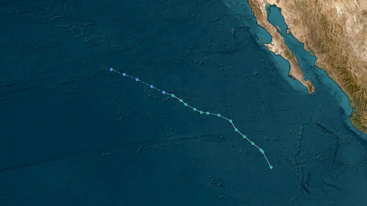
Hernan formed as a tropical storm on August 13, 2026. It reached peak strength with winds near 40 mph (65 km/h) and a central pressure of 1004 mb. The National Hurricane Center issued its final advisory on August 15. The storm never made landfall or approached any populated coastline.
Brief Peak, Swift Fade: Tropical Storm Hernan in the Open Pacific
Hernan, designated EP082026, developed in the eastern North Pacific during a short period of tropical activity. At peak intensity, maximum sustained winds reached about 40 mph (65 km/h), while the minimum central pressure fell to 1004 mb.
The circulation remained over open water throughout its tropical-storm phase. Hernan stayed well west of Mexico and thousands of miles east of the Philippines, far from the Western Pacific and South China Sea, where East Asian typhoon threats typically develop.
Hernan's cloud pattern was uneven near its peak. Thunderstorms were concentrated away from the low-level center rather than forming a tight, persistent core. Strong vertical wind shear kept the convection displaced and limited further strengthening.
The storm never reached hurricane intensity. Its highest recorded winds remained near 40 mph, and the 1004-mb pressure minimum marked its strongest point before the circulation began to weaken.
The storm's effects were limited to rough seas and strong winds near its center. With no landfall and no coastal watches or warnings, Hernan remained a marine weather event over the open eastern Pacific. The National Hurricane Center's archive identifies EP082026 as the eighth numbered eastern-Pacific system of the 2026 season.
August 14–15: Hernan Weakens as Thunderstorms Pull Away
Hernan weakened quickly on August 14 as thunderstorms pulled away from the center. The low-level circulation became increasingly exposed, while the remaining convection lost the organization needed to maintain tropical-storm strength.
The weakening continued into August 15. Wind speeds fell below tropical-storm intensity, and the system lost its organized tropical structure as it moved westward over the Pacific.
The official ATCF record shows Hernan at 30 kt near 161°N? No—the encoded position is 16.1°N, 134.9°W at 1500 UTC, followed by a remnant-low classification as the system moved west. The final operational record lists 25-kt winds and a 1009-mb pressure at 2100 UTC August 15.
At 2100 UTC on August 15, the center was at 15.8°N, 135.9°W. Maximum sustained winds were 25 kt (30 mph), and the central pressure was 1009 mb.
The final advisory placed the remnant roughly 1,535 miles (2,470 km) west-southwest of the southern tip of Baja California. Hernan remained over open water and never made landfall.
Hernan's eastern-Pacific track kept it thousands of miles from the Philippines, Japan, China, and Vietnam, with no coastal warnings issued anywhere in the region. The system never crossed into the Western Pacific or South China Sea.
The National Hurricane Center maintains the official advisory archive and historical data for eastern North Pacific tropical cyclones.
Default Best Recommendation
For a historical record of Hernan, the key reference points are its EP082026 designation, August 13–15 lifespan, peak winds of about 40 mph (65 km/h), minimum pressure of 1004 mb, and final remnant-low position and intensity.
The storm is best classified as a short-lived eastern North Pacific tropical storm rather than a Western Pacific typhoon. Its track remained over open Pacific waters, with no landfall and no coastal watches or warnings.
The National Hurricane Center's ATCF archive also preserves the operational forecast and track data for EP082026, including the final 25-kt, 1009-mb remnant-low entry.
FAQ: Hernan 2026 Facts, Track, and Final Status
When did Hernan form?
Hernan became a tropical storm on August 13, 2026, in the eastern North Pacific.
What was Hernan's system number?
Its eastern-Pacific designation was EP082026.
How strong did Hernan become?
Hernan peaked as a tropical storm with maximum sustained winds of about 40 mph (65 km/h).
What was its lowest central pressure?
The minimum central pressure was 1004 mb.
Did Hernan become a hurricane?
No. It remained below hurricane strength throughout its tropical life.
How long did Hernan last?
The storm's tropical-cyclone lifespan was August 13–15, 2026 (UTC).
When did Hernan become a remnant low?
Hernan lost tropical-storm status on August 15 as its organized circulation weakened.
Where was Hernan at 2100 UTC on August 15?
The center was at 15.8°N, 135.9°W.
What were the final winds?
Maximum sustained winds were 25 kt (30 mph).
What was the final central pressure?
The final pressure was 1009 mb.
Did Hernan make landfall?
No. The system remained over open ocean.
Were coastal warnings issued?
No coastal watches or warnings were issued for Hernan.
Did Hernan threaten the Philippines?
No. Its eastern-Pacific track remained thousands of miles east of the Philippines.
Did Hernan affect Japan, China, or Vietnam?
The storm remained far from East Asian coastal areas and did not make landfall there.
How far was Hernan from Baja California when it ended?
The remnant was about 1,535 miles (2,470 km) west-southwest of the southern tip of Baja California.
Why did Hernan weaken?
Thunderstorms pulled away from the center, while vertical wind shear disrupted the storm's circulation and prevented sustained tropical organization.
Was Hernan a Western Pacific typhoon?
No. Hernan was an eastern North Pacific tropical storm, tracked by the National Hurricane Center under the EP082026 designation.
The final advisory placed the remnant low at 15.8°N, 135.9°W, with winds of 25 kt and pressure at 1009 mb.