

Dujuan 2026: Rapid Rise, Japan Floods and a Rare Northward Track
Bottom line: Typhoon Dujuan was a Western Pacific cyclone whose main land impacts occurred in Japan rather than the Philippines, mainland China, Taiwan, or the South China Sea. The Japan Meteorological Agency best-track record places its formation on September 16, 2026, with a minimum central pressure of 960 hPa and maximum sustained winds of 75 knots before the cyclone moved northeast of Japan and ended its tropical-cyclone phase on September 22. The most serious measured consequence was rainfall: Oshima in the Izu Islands received roughly 600 mm in 24 hours during the peak event, while intense rain triggered landslide, flood, transport and power-disruption risks across eastern Japan. For the Philippines and southern China, Dujuan remained offshore, while Japan became the principal physical-impact zone as the storm passed near the Izu Islands and east of the Kanto region.
Western Pacific Genesis: How Dujuan Built a Fast Northbound Track
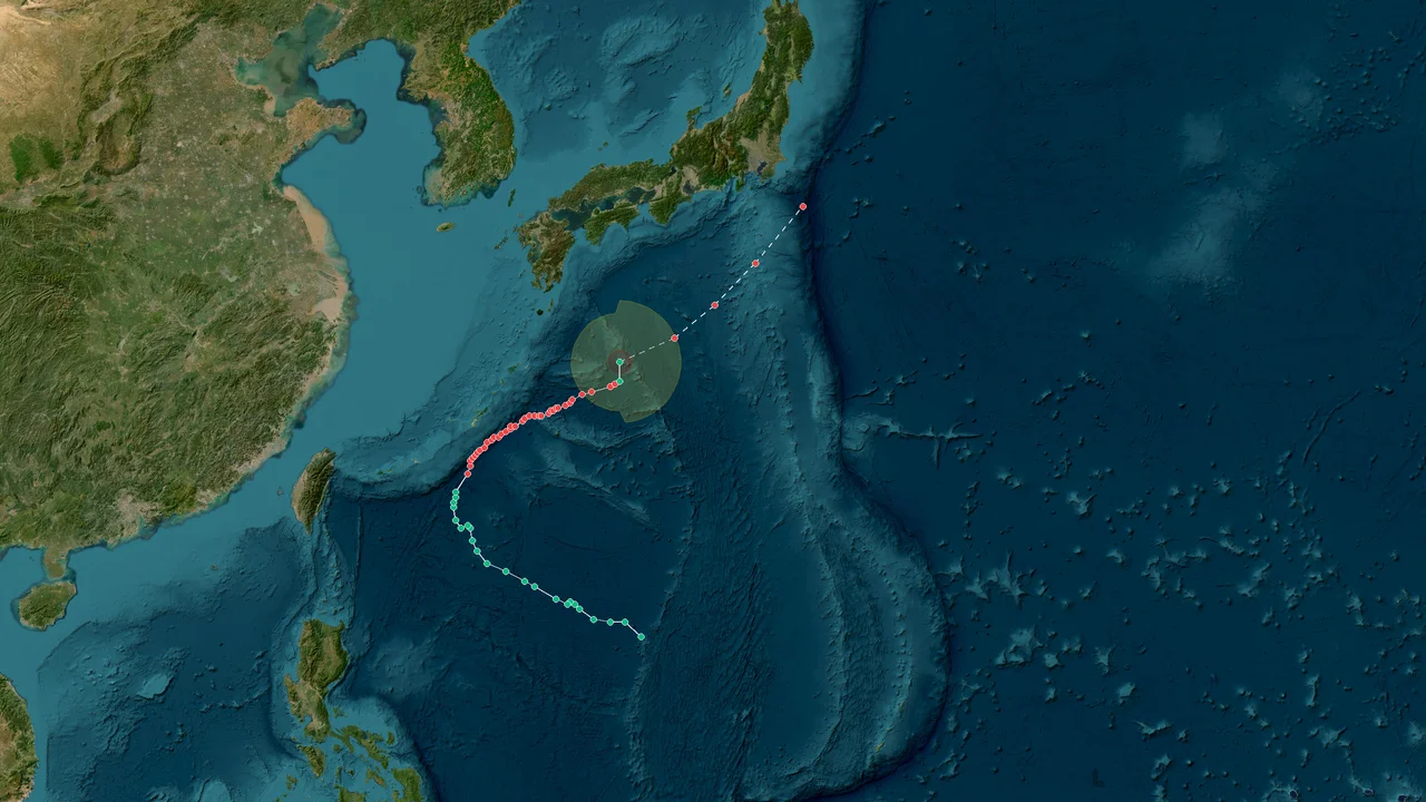
Dujuan formed near 16.4°N, 149.4°E on September 16 and then accelerated northward across the open Western Pacific, keeping its core circulation well east of the Philippines before turning toward Japan. The Digital Typhoon archive, based on Japan Meteorological Agency best-track data, records the system from September 16 through September 22, giving the tropical cyclone a six-day analyzed lifetime and a total track length of roughly 4,338 km.
The early trajectory was the first major clue to the eventual impact pattern. Dujuan did not spend its formative period tracking westward toward Luzon, Taiwan or the South China Sea. Instead, it gained latitude over open water and gradually established a path toward the Japanese island chain.
That geometry reduced the direct threat to the Philippines even as the storm strengthened. On September 17, Philippine meteorological authorities were monitoring Dujuan well outside the Philippine Area of Responsibility. The storm was roughly 2,970 km east of northern Luzon in the early hours, with maximum sustained winds around 75 km/h and north-northeastward movement near 20 km/h. Later that day, the system had strengthened and was moving much faster toward the north.
By September 18, Dujuan was about 2,190 km east-northeast of extreme northern Luzon, with sustained winds around 110 km/h and gusts near 135 km/h. Its center was still far offshore, and the track continued to carry it away from the main Philippine islands.
That distinction matters in a retrospective because tropical-cyclone seasons often produce overlapping weather signals. Rain in the Philippines during the same period does not automatically belong to Dujuan. Philippine weather bulletins were also tracking the southwest monsoon, the Intertropical Convergence Zone and other local disturbances. Those systems could produce showers and thunderstorms independently of Dujuan.
The track geometry that separated the Philippines from Japan
By September 18, Dujuan had shifted decisively into a northbound track, placing the Izu Islands and Kanto region ahead of the cyclone while leaving the Philippines outside the core wind field. This northward motion became the defining feature of the storm's life cycle.
A tropical cyclone moving at 25 to 30 km/h can cover several hundred kilometers in a single day. Forecast changes therefore have operational consequences for shipping, aviation, coastal construction and emergency management even when the storm center remains hundreds of kilometers offshore.
Japanese forecasts began focusing increasingly on the Izu Islands and Kanto as Dujuan approached from the south. Reports on September 18 described the storm as a threat to eastern Japan during the Silver Week holiday period, with heavy rain and strong winds becoming the main concerns.
The storm's growing rain shield was especially important. The eventual disaster footprint was not determined solely by the location of the center. Dujuan carried tropical moisture northward into an environment where mountainous terrain and atmospheric boundaries could enhance rainfall.
This produced a widening gap between the cyclone's meteorological center and the locations where the most serious hazards developed.
The Philippine case shows the same principle from the opposite direction. The storm could be strong enough to qualify as a significant typhoon while remaining geographically too far east and north to create a comparable Philippine land disaster.
Dujuan's operational benchmark matrix
Dujuan's measurable stress points were a 960 hPa minimum central pressure, 75-knot peak sustained wind, a large gale-force wind field and extreme rainfall exceeding 600 mm in 24 hours around Oshima, making rainfall accumulation more representative of the Japanese land hazard than the peak wind number alone.
| :: | :: | :: |
Indicator Dujuan 2026 record Interpretation
Formation September 16, 2026 Western Pacific tropical-cyclone development
JMA best-track end September 22, 2026 Six-day tropical-cyclone phase
Minimum central pressure 960 hPa Peak analyzed intensity
Maximum sustained wind 75 kt Peak JMA wind estimate
Maximum storm-wind radius About 100 nm Broad inner wind field
Maximum gale-force wind diameter About 950 km Large regional exposure
Total track length About 4,338 km Long northward journey
Oshima 24-hour rainfall About 600 mm or more Extreme hydrological loading
Reported Oshima 24-hour total 686.5 mm by 5:20 p.m. More than a typical September monthly total
Chichijima maximum gust 20.2 m/s Strong local wind before the main approach
Primary Japanese disaster mechanism Rainfall and landslides More consequential than direct eyewall wind
These figures also explain why the storm cannot be reduced to a single intensity category.
A 75-knot peak tells us how strong the circulation became. It does not tell us where the worst damage occurred.
The rainfall observations tell a different part of the story. More than 600 mm in a day represents a massive hydrological load, especially on steep island terrain.
The large wind field tells a third part. Strong winds can affect shipping, aviation, power networks and coastal structures well outside the center.
The complete event therefore emerges only when all three dimensions are considered together.
Frequently Asked Questions About Typhoon Dujuan 2026
Did Dujuan make landfall in mainland China?
No direct mainland-China landfall occurred in the 2026 Dujuan event; the cyclone's northward track carried its core away from the South China Sea and toward Japan.
Southern China remained outside the principal core-impact zone. Hong Kong Observatory forecasts during the approach described hot conditions, showers and thunderstorms in southern China rather than a direct typhoon strike.
Did Dujuan directly hit the Philippines?
No, Dujuan remained outside the Philippine Area of Responsibility while it strengthened and moved northward, keeping its core circulation well east of northern Luzon.
Philippine authorities were nevertheless monitoring the storm because of its strength and its location within the wider Western Pacific.
Rain occurring in the Philippines during the same period should be attributed to the responsible local weather systems rather than automatically assigned to Dujuan.
Did Dujuan hit Taiwan?
Taiwan remained outside the principal Dujuan impact corridor because the storm continued northward over the Pacific rather than crossing Taiwan or entering the Taiwan Strait.
The cyclone's steering pattern ultimately favored Japan as the main land-impact region.
Did Hong Kong or Macau experience a direct Dujuan strike?
No direct core strike occurred over Hong Kong or Macau; the storm remained far to the north and east while southern China experienced a separate local weather pattern.
Hong Kong Observatory bulletins during September 20–21 placed Dujuan south of Japan and described local conditions in the Guangdong region independently of the typhoon's core circulation.
Why was Japan affected so severely if Dujuan did not make a direct landfall?
Japan's worst impacts came from extreme rainfall and landslides, not simply from the exact location of the typhoon center.
Oshima received roughly 600 mm or more in 24 hours during the peak event. Mountainous terrain then converted exceptional rainfall into slope instability, while urban drainage systems, roads and utilities faced additional stress.
A cyclone can therefore cause serious damage without placing its eye over land.
What was Dujuan's peak intensity?
The JMA-based best-track record gives Dujuan a minimum central pressure of 960 hPa and maximum sustained winds of 75 knots.
Those are best-track parameters and should not be mixed with wind estimates from agencies using different averaging periods.
How long did Dujuan last?
The JMA best-track tropical-cyclone record runs from September 16 to September 22, 2026, giving the system a six-day tropical-cyclone phase.
The weather and recovery consequences lasted beyond that period because flooding and landslide hazards do not disappear when the cyclone center leaves the region.
What was the most important hazard?
For eastern Japan, extreme rainfall was more consequential than the storm's peak wind speed because rainfall saturation directly increased landslide and flood risk.
Oshima's extreme accumulation and the subsequent landslide warnings demonstrate the difference between atmospheric intensity and ground-level hazard.
What should be checked before publishing a final Dujuan report?
A reliable retrospective should verify the best track, local rainfall observations, warning levels and casualty figures independently because operational numbers can change after post-storm analysis.
The following checklist provides a practical publication audit.
Publication and Verification Checklist
Confirm the cyclone identity as Western Pacific Typhoon Dujuan, international designation 2625.
Verify formation and end dates against the latest JMA-based best-track data.
Use 960 hPa and 75 knots only when describing the relevant best-track peak intensity.
Distinguish JMA sustained-wind methodology from agencies using different averaging periods.
Confirm that Dujuan remained outside the Philippine Area of Responsibility during the relevant Philippine bulletins.
Separate Philippine rainfall linked to the southwest monsoon, Intertropical Convergence Zone or local disturbances from rainfall directly attributable to Dujuan.
Verify the northward track before describing Japan as the principal land-impact region.
Check Oshima rainfall totals by observation time because reported 24-hour totals changed as the event continued.
Distinguish rainfall observations from forecast rainfall amounts.
Treat landslide warnings as local hazard information rather than direct proxies for central pressure or wind speed.
Verify Japanese casualty, missing-person and infrastructure figures against the latest official releases before publication.
Keep mainland China, Hong Kong, Macau and Taiwan separate from the Japanese core-impact narrative.
Identify whether every numerical figure is an operational observation, forecast estimate or post-event best-track analysis.
Update damage and casualty statistics when Japanese authorities issue revised totals.
Preserve the distinction between the six-day tropical-cyclone lifecycle and the longer recovery period.
Check the final storm classification and post-tropical status before describing the end of the system.
Avoid attributing every regional rain event during September 2026 to Dujuan without a documented meteorological connection.
Dujuan's final measurable signature is a fast-moving Western Pacific typhoon that reached 960 hPa and 75 knots, developed a broad wind field, passed close enough to eastern Japan to deliver extreme rainfall, and left its strongest documented land impacts in the form of flooding, landslides, transport disruption and power interruptions. Its JMA best-track tropical-cyclone phase ended on September 22, while saturated slopes, damaged infrastructure and post-storm recovery operations continued after the circulation had moved away from Japan.